Fairfax County is using the results of the Reston Network Analysis Group (RNAG) final analysis of traffic demand and improvements for the next three decades to guide its planning of Reston roadway improvements. In the following paper, John Mooney, RA Board of Directors, takes a look at some of the shortcomings in that analysis.
Reston Spring

Reston Spring
Showing posts with label Traffic analysis. Show all posts
Showing posts with label Traffic analysis. Show all posts
Thursday, October 18, 2018


Monday, June 26, 2017
Monday, May 1, 2017
Op-Ed: The County’s Reston Transit Station Area Planning Deception, Terry Maynard, RestonNow, April 24, 2017
The following is the text of an op-ed written by Terry Maynard, Reston 20/20 Co-Chair, and published in RestonNow on April 24, 2017. The only difference between this printing and that in RestonNow is that we have included here the spreadsheet used to develop the conclusions reached in the RestonNow publication.
Our County Board of Supervisors, led by Chairman Sharon Bulova, is in the process of overbuilding and underserving residents in Reston and across the county. The result will be the eroding livability of Reston and other county areas facing urbanization.
And this is being accomplished by a simple arithmetical trick: Overstating the amount of space new housing and office space require to accommodate residents and workers. Very simply, county planners continue to overstate the space needed for office workers as 300 gross square feet (GSF) per worker when studies globally over nearly a decade show it is now under 200 GSF/worker and could be headed to 150 GSF/worker.
At the same time, as it started to plan for Tysons’ redevelopment nearly a decade ago, the County raised its planning assumption for the size of station area dwelling units (DUs) from 1,000 GSF/DU to 1,200 GSF/DU. Nonetheless, a County planning study for Tysons showed then (2007) that the average size of Tysons residents was 1,100 GSF, mostly in garden apartments before the recent advent of massive high-rise residential development there.
Now, the average high-rise DU size is shrinking well below 1,000 GSF/DU, more than offsetting the few mid-rise and single-family attached DUs in station areas, as some recent Reston development proposals show:
The impact is straightforward: The resulting planned densities (total GSF of development divided by the square footage of the lot on which it sits) will allow half-again as many office workers and 28 percent more residential units than the County plan officially intends. Yet developers and the County are only planning to provide services — improved roads, schools and parks, and more — based on the lower count envisioned in the plan. The result will be reduced services and higher taxes.

So what does that mean for “real people?” Based on GSF information provided by FCDOT to the Supervisors serving as the Board Transportation Committee, the current Reston station area plan offers the potential for 76,280 added residents (at 2.0 residents/DU) and 29,059 added office worker jobs (at 300GSF/worker) in the next four decades.
If instead of using the County’s faulty planning assumptions, we use real world experience, we can anticipate that the allowable development could result in an addition of 101,492 total residents in 50,746 DUs and 78,559 office workers, including retrofitted office buildings, market conditions permitting.
More specifically, it suggests an order of magnitude explosion in residents (11,720 in 2010 vs. 113,212 then) and more than twice as many office employees (69,941 in 2010 vs. 148,500 then) in Reston’s station areas. Overall, Reston can expect twice as many people living and working in the station areas as is anticipated by the Reston plan.
Let’s take a look at some areas where this will affect Restonians and others similarly affected by these false development assumptions.
TRAFFIC: We are near the end of the painful two-year RNAG experience, a truly dysfunctional FCDOT-managed, Board initiative based on false assumptions about an alleged “funding gap,” to address the worsening traffic conditions that will come with the urbanization of Reston’s station areas. Already the County has reduced the standard for intersection traffic service levels to a new “urban standard” in which “unstable flow, operating at capacity” is good enough, and Reston’s station area streets don’t have to try to meet community needs for traffic from, to, and especially through the station areas, including Dulles Toll Road users.
In doing its planning, FCDOT has been using the forecast employment and residential data it says area in the Reston Master Plan. Unfortunately, instead of 41,455 added people, the increase is likely to be 90,955 people — some 63.5 percent greater than what FCDOT is planning.
We all know the two major consequences of that result: Worse traffic congestion for Restonians driving near the station areas and ever higher Transportation Service District (TSD) taxes on the residents of the station areas.
SCHOOLS: There may be no single issue of greater concern to Reston families (and those countywide) than the availability of quality public school education for their children. Like traffic, the quality of our children’s education is likely to erode because of the County’s insistence on unrealistic population forecasts that under-estimate the need for classroom capacity.
Using data in a 2012 FCPS letter to the County’s Planning Department regarding the future of Reston schools, we can update FCPS’ forecast of the number of students in the decades ahead. This requires, first, updating the understated population from Scenario “G” prepared for the Reston planning task force to the plan’s expectations and then updating that to our estimate of future Reston station area population. The result more than doubles the number of dwelling units (and, therefore, the number of students) in station area schools — from 24,559 in Scenario “G” to 56,606 in our forecast.
Applying FCPS’ planning parameters for student yield ratios and mixes laid out in that letter, we calculate that Reston can expect about 6,700 new students from the station areas to be added to the 11,000 students now in all Reston’s schools over the next four decades. That’s about:
PARKS: The County’s Urban Parks Framework and the Countywide Adopted Service Level Standards for Athletic Fields establish guidance for park size and recreational facilities. Suffice it to say that the Reston plan does not remotely try to achieve the guidance laid out in these documents based on the County’s faulty assumptions, much less our adjusted estimate of future population and employment growth.
The prospective population and employment totals should mean the availability of more than 187 acres of parks within 1/2-mile of the Metro stations under the Urban Parks Framework. That’s about 1/8 of Reston’s total station area. Given preliminary notions of additional mid-sized parks in north and south Town Center plus one in the Wiehle station area, we think it may be possible to reach 90 acres of public and private parks in Reston’s station areas four decades from now. Bottom line: Reston’s station areas will have fewer park acres per capita than Manhattan does now.
The County master plan also sets as “a goal” the construction of 12 ballfields at 2.2 million GFA (50 acres) in Reston’s station areas, and a minimum of three. Yet the County’s population-based facilities guideline for the 113,212 people who our adjusted plan suggest may live in the station areas calls for 35 ballfields, nearly triple the plan’s most optimistic “goal” and an order of magnitude greater than its meager minimum objective for Reston.
Aside from the impact on livability and total disregard for Reston planning principles, the ruinous shortage of open space, parks and recreational facilities in the station areas will almost certainly see RA’s facilities overrun with non-RA members no matter what the price for non-member use.
But the Board of Supervisors doesn’t care. The more development there is, the more property tax revenues it generates, and the more the Board can spend without raising those tax rates or adding new taxes on voters. Even so, however, we’ve just seen the Board add the TSD tax on Reston’s station area residents essentially because it can get away with it. It is certainly unjustified as we’ve commented here before. Will they also be taxed to provide schools or parks to meet the explosive growth?
What you need to know is that, like the new Reston station area TSD tax, Restonians (and others) are being misled by their Board and the County staff on the scope of County urbanization plans and their tremendously adverse and virtually immutable impact on our community, including your quality of life. We all will continue to be misled until we replace this cabal with responsible and responsive leaders and staffers of integrity.
Our County Board of Supervisors, led by Chairman Sharon Bulova, is in the process of overbuilding and underserving residents in Reston and across the county. The result will be the eroding livability of Reston and other county areas facing urbanization.
And this is being accomplished by a simple arithmetical trick: Overstating the amount of space new housing and office space require to accommodate residents and workers. Very simply, county planners continue to overstate the space needed for office workers as 300 gross square feet (GSF) per worker when studies globally over nearly a decade show it is now under 200 GSF/worker and could be headed to 150 GSF/worker.
At the same time, as it started to plan for Tysons’ redevelopment nearly a decade ago, the County raised its planning assumption for the size of station area dwelling units (DUs) from 1,000 GSF/DU to 1,200 GSF/DU. Nonetheless, a County planning study for Tysons showed then (2007) that the average size of Tysons residents was 1,100 GSF, mostly in garden apartments before the recent advent of massive high-rise residential development there.
Now, the average high-rise DU size is shrinking well below 1,000 GSF/DU, more than offsetting the few mid-rise and single-family attached DUs in station areas, as some recent Reston development proposals show:
- JBG/Wiehle and partners plan for 1,300-1,500 residential units in 1.2 million GSF of development in two 5-story buildings, or 800-925 GSF/DU;
- Golf Course Plaza proposes 413 DUs in a 392,600 GSF multi-family building or 950 GSF/DU, also in 5-story structures;
- Faraday’s proposes redeveloping the area just south of Wiehle Station with up to 500 apartments in two buildings with about 487,000 GSF of residential space that will reach about 975 GSF/DU according to its plan submission.
- Lerner Enterprises is planning a 457-“luxury apartment” complex called Excelsior Park with average unit size at about 1,050 GSF in 423,587 rentable square feet (RBA), which equates to 481,350 GSF.
The impact is straightforward: The resulting planned densities (total GSF of development divided by the square footage of the lot on which it sits) will allow half-again as many office workers and 28 percent more residential units than the County plan officially intends. Yet developers and the County are only planning to provide services — improved roads, schools and parks, and more — based on the lower count envisioned in the plan. The result will be reduced services and higher taxes.
So what does that mean for “real people?” Based on GSF information provided by FCDOT to the Supervisors serving as the Board Transportation Committee, the current Reston station area plan offers the potential for 76,280 added residents (at 2.0 residents/DU) and 29,059 added office worker jobs (at 300GSF/worker) in the next four decades.
If instead of using the County’s faulty planning assumptions, we use real world experience, we can anticipate that the allowable development could result in an addition of 101,492 total residents in 50,746 DUs and 78,559 office workers, including retrofitted office buildings, market conditions permitting.
More specifically, it suggests an order of magnitude explosion in residents (11,720 in 2010 vs. 113,212 then) and more than twice as many office employees (69,941 in 2010 vs. 148,500 then) in Reston’s station areas. Overall, Reston can expect twice as many people living and working in the station areas as is anticipated by the Reston plan.
Let’s take a look at some areas where this will affect Restonians and others similarly affected by these false development assumptions.
TRAFFIC: We are near the end of the painful two-year RNAG experience, a truly dysfunctional FCDOT-managed, Board initiative based on false assumptions about an alleged “funding gap,” to address the worsening traffic conditions that will come with the urbanization of Reston’s station areas. Already the County has reduced the standard for intersection traffic service levels to a new “urban standard” in which “unstable flow, operating at capacity” is good enough, and Reston’s station area streets don’t have to try to meet community needs for traffic from, to, and especially through the station areas, including Dulles Toll Road users.
In doing its planning, FCDOT has been using the forecast employment and residential data it says area in the Reston Master Plan. Unfortunately, instead of 41,455 added people, the increase is likely to be 90,955 people — some 63.5 percent greater than what FCDOT is planning.
We all know the two major consequences of that result: Worse traffic congestion for Restonians driving near the station areas and ever higher Transportation Service District (TSD) taxes on the residents of the station areas.
SCHOOLS: There may be no single issue of greater concern to Reston families (and those countywide) than the availability of quality public school education for their children. Like traffic, the quality of our children’s education is likely to erode because of the County’s insistence on unrealistic population forecasts that under-estimate the need for classroom capacity.
Using data in a 2012 FCPS letter to the County’s Planning Department regarding the future of Reston schools, we can update FCPS’ forecast of the number of students in the decades ahead. This requires, first, updating the understated population from Scenario “G” prepared for the Reston planning task force to the plan’s expectations and then updating that to our estimate of future Reston station area population. The result more than doubles the number of dwelling units (and, therefore, the number of students) in station area schools — from 24,559 in Scenario “G” to 56,606 in our forecast.
Applying FCPS’ planning parameters for student yield ratios and mixes laid out in that letter, we calculate that Reston can expect about 6,700 new students from the station areas to be added to the 11,000 students now in all Reston’s schools over the next four decades. That’s about:
- 3,700 elementary school kids (about five average-sized Reston elementary schools),
- 1,000 middle schoolers (about the enrollment at Langston Hughes), and
- 2,000 high schoolers (nearly South Lakes’ enrollment).
PARKS: The County’s Urban Parks Framework and the Countywide Adopted Service Level Standards for Athletic Fields establish guidance for park size and recreational facilities. Suffice it to say that the Reston plan does not remotely try to achieve the guidance laid out in these documents based on the County’s faulty assumptions, much less our adjusted estimate of future population and employment growth.
The prospective population and employment totals should mean the availability of more than 187 acres of parks within 1/2-mile of the Metro stations under the Urban Parks Framework. That’s about 1/8 of Reston’s total station area. Given preliminary notions of additional mid-sized parks in north and south Town Center plus one in the Wiehle station area, we think it may be possible to reach 90 acres of public and private parks in Reston’s station areas four decades from now. Bottom line: Reston’s station areas will have fewer park acres per capita than Manhattan does now.
The County master plan also sets as “a goal” the construction of 12 ballfields at 2.2 million GFA (50 acres) in Reston’s station areas, and a minimum of three. Yet the County’s population-based facilities guideline for the 113,212 people who our adjusted plan suggest may live in the station areas calls for 35 ballfields, nearly triple the plan’s most optimistic “goal” and an order of magnitude greater than its meager minimum objective for Reston.
Aside from the impact on livability and total disregard for Reston planning principles, the ruinous shortage of open space, parks and recreational facilities in the station areas will almost certainly see RA’s facilities overrun with non-RA members no matter what the price for non-member use.
But the Board of Supervisors doesn’t care. The more development there is, the more property tax revenues it generates, and the more the Board can spend without raising those tax rates or adding new taxes on voters. Even so, however, we’ve just seen the Board add the TSD tax on Reston’s station area residents essentially because it can get away with it. It is certainly unjustified as we’ve commented here before. Will they also be taxed to provide schools or parks to meet the explosive growth?
What you need to know is that, like the new Reston station area TSD tax, Restonians (and others) are being misled by their Board and the County staff on the scope of County urbanization plans and their tremendously adverse and virtually immutable impact on our community, including your quality of life. We all will continue to be misled until we replace this cabal with responsible and responsive leaders and staffers of integrity.
Friday, April 1, 2016
Reston doesn't need no stinkin' traffic lights!
Well, we may all need to have self-driving cars. Anyway, look at this MIT vision of future intersections.
Maybe RNAG and FCDOT could take a lesson as they work on re-shaping intersections in Reston's urbanizing areas.
Tuesday, February 2, 2016
Thursday, August 14, 2014
WMATA notes the importance of residential density near Metro stations to increase ridership.
In a post on its official blog, PlanItMetro, WMATA makes a point that we made three years ago to the Reston Task Force: The more residents living near a Metro station, the greater will be Metro ridership. Here's what WMATA has to say:
The results and certainly the conclusions are similar to a short, more technical paper we wrote for the Reston Task Force and posted on this blog in 2011 entitled, "The Residential vs. Employment Balance in TOD Areas: Optimizing for Reduced Congestion and Environmental Damage." The two key graphics in that report show that residents of a Metro station area "walk shed" ("the half-mile circle") are much more likely to use Metro than people who work in that station area. They also show the converse: That people who work in a station area are much more prone to drive to that station area at any given distance from the station than are the people who live there.

Metro cares about transit walk sheds because more households accessible to transit by walking translates directly into more ridership.
We’ve been focusing a lot on transit walk sheds lately. We’ve shown that the size of a transit walk shed depends heavily on the roadway network and pedestrian infrastructure, and that these sizes vary dramatically by Metrorail station. We’ve also demonstrated that expanding the walkable area can make hundreds of households walkable to transit.
But why do we care so much about walk sheds? Because larger walk sheds mean more households in the walk shed, and that means ridership. For example, we’d be hard pressed to find many households in Landover’s small walk shed, so it’s no surprise that walk ridership at that station is low. On the other hand, thousands of households are within a reasonable walk to Takoma’s larger walk shed, and walk ridership there is much higher.
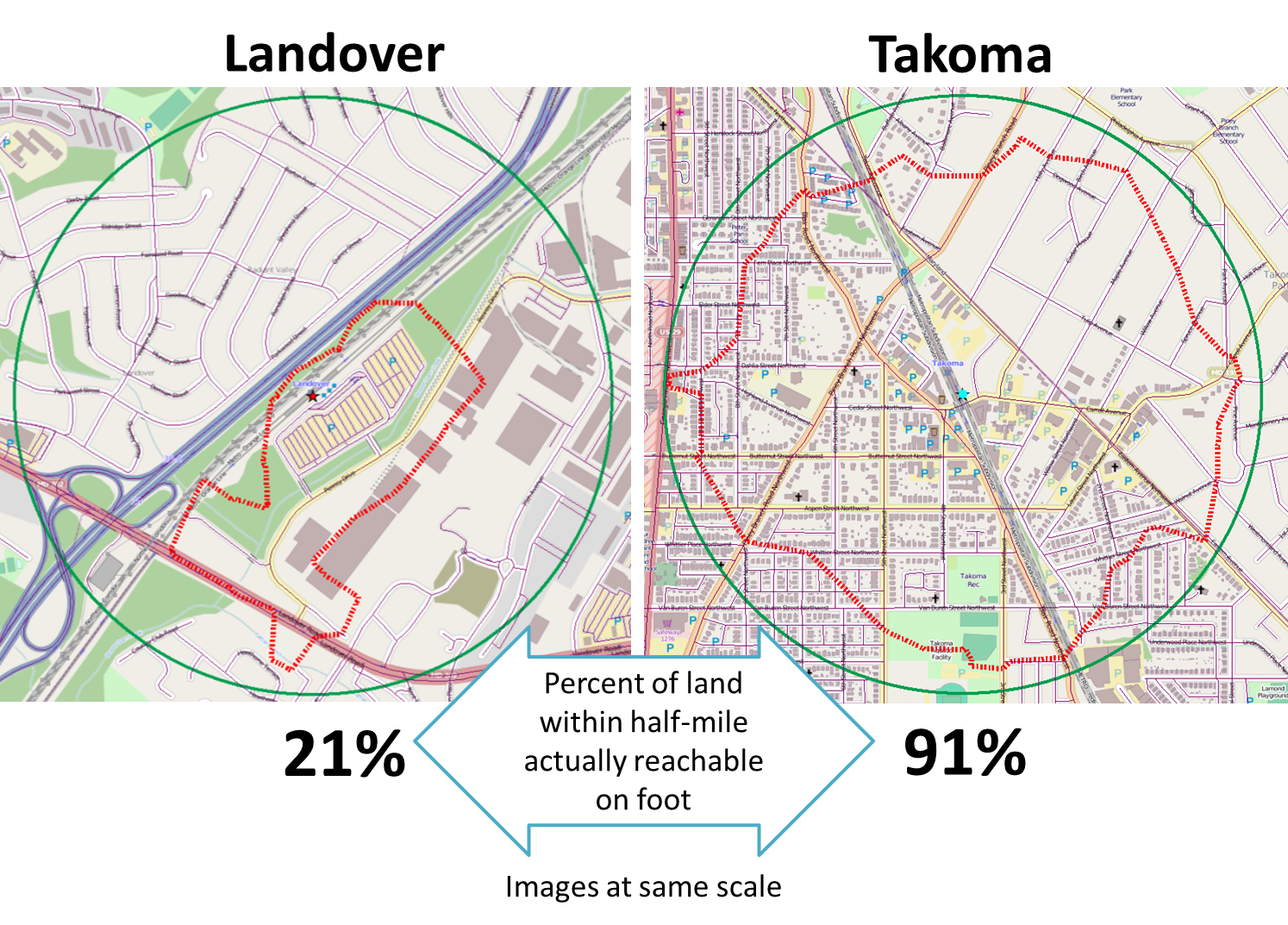
In other words, the more people can walk to transit, the more people do walk to transit – and data across Metrorail stations prove it:
 |
| More households in the walkable area around a Metrorail station means higher ridership. |
The chart above shows that the number of households in a Metrorail station entrance’s walk shed is highly correlated with AM Peak walk ridership at that station. In fact, the number of households walkable to a Metrorail station alone explains nearly 70% of the variation in walk ridership across Metrorail stations.Click here to read the rest of this post.
The results and certainly the conclusions are similar to a short, more technical paper we wrote for the Reston Task Force and posted on this blog in 2011 entitled, "The Residential vs. Employment Balance in TOD Areas: Optimizing for Reduced Congestion and Environmental Damage." The two key graphics in that report show that residents of a Metro station area "walk shed" ("the half-mile circle") are much more likely to use Metro than people who work in that station area. They also show the converse: That people who work in a station area are much more prone to drive to that station area at any given distance from the station than are the people who live there.
Our report was based on a 2005 WMATA survey of Metrorail ridership. Since we are unaware of any more recent such surveys, we suspect the PlanItMetro article is a more fine-grained analysis of the same report. The results in both these reports is consistent with a significant body of research on the topic: Residents of a transit station area are much more likely to use transit than workers in the station area.
Nonetheless, the point received absolutely not attention by the developer-driven task force, which was intent on allowing massive office space development and little residential development, especially within the critical first 1/4 mile of the Metro station. This was especially true in the Town Center area. Even advocates for Metrorail on the task force, including its DCRA President chairman, did not grasp--or chose to ignore--the importance of nearby residential development to Metrorail ridership. The same was true to an even much greater extent in the Tysons Task Force.
In the end, the County planning staff modestly muted the jobs-to-residential ratio and density (total square footage of allowable developed space) in the final plan subsequently approved by the County Board in the face of traffic analyses that showed even more massive gridlock than we can expect under the approved plan. The final density, most notably in Reston Town Center, is less than proposed by the task force's Town Center Sub-committee, dominated by Boston Properties and its allies, and a better balance, that is, more residential, than the sub-committee proposed. Still, the County's analysis of the approved development plan shows that, when the planned development is completed, Restonians can expect five-minute or more traffic delays at each intersection along the key through streets (Reston Parkway, Wiehle) in the station area during peak traffic periods--even if all the planned street infrastructure is in place!
And none of this considers the much reduced--and declining--office space per worker now seen in office property leasing. Recent trends reported here several times in letters to Board Chairman Sharon Bulova (see here, here, here, and here) show that the office space per worker is being cut by half at least for a variety of reasons, meaning we can anticipate at least twice as many workers in the allowed plan office space than the plan envisions--and about twice as much traffic as has been assessed.
All of this belies the stated goal of Reston Master Plan re-make to take advantage of the arrival of Metrorail since little the task force did actually took advantage of the transit opportunities the arrival of Metrorail presents. Rather it was about increasing developer and landowner profit opportunities and especially the County's real estate property tax base. Unfortunately, the turn in the economy and the reduction of federal spending has shown all the growth assumptions prepared by developer-funded GMU's Center for Regional Analysis, including the developer controlled "2030 Group" lobbying entity, to be grotesquely optimistic. With little prospect that government spending will suddenly return to pre-recession levels over the next decade or so, the ill-considered tax revenue goals of the County and the grand lease increases envisioned by the developer community appear unlikely to unfold.
Nonetheless, the now irrevocable legal commitment to office-focused development in the station area means that, whatever happens, there will be fewer riders taking Metrorail than could have been under a more balanced plan focusing on greater residential development in Reston and Tysons station areas.
Subscribe to:
Posts (Atom)